fourteener (fore TEEN er) - in mountaineering, a mountain that exceeds 14,000 feet above mean sea level
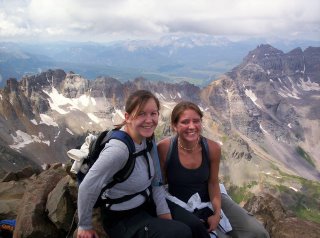
It looks fake, but honestly, this is one of the views from atop Mount Sneffels in western Colorado. Dear Friend and I are pictured here after an arduous climb!
But let me begin at the beginning:
Chapter 1: The Springs to Montrose
We left Friday afternoon, after my Dear Friend's husband finally arrived home from work, later than expected. We packed up the car, complete with the three of ourselves and their little 4 month-old son, and began the 4-hour drive to Montrose, Colorado, at about 7pm.
About an hour away from Montrose (where lives Dear Friend's mother) we stopped for gas. The attendants were closing up shop, but graciously let us use their restrooms for much-needed restroom usage, including diaper change! However, after filling up the tank, the car refused to start. Dear friend's husband tried to push-start it by popping the clutch--with all of us, and the luggage, inside--after a full day's work of landscaping with an already-sore back. We were not sure what he was doing until after he tried, but by then, he had really twisted his back and was hurting. Unsure if a push-start would help the situation, anyway, my dear friend called the towing company.
While we waited, Dear Friend's husband leaned over the trunk of the car while I stood on the bumper and tried to manipulate his thoracic spine. (must've looked quite professional, I say!)
The gentleman that came to assist us helped get the car push-started (which we should have tried again, but oh well) and then charged a $35 service fee! We actually had to follow him to his office so that he could run the credit card! Grrrh.
Finally on the road to Montrose again, we got pulled over by a policeman. Since dear husband's friend was not sure of the speed limit, he was going a little over 60mph. Apparently, the limit was 55mph. Fortunately, Dear Friend herself had just replaced Baby Boy into the carseat in the back right before we were pulled over. The officer was very kind and only gave a warning--after asking how our trip was going so far!
We arrived in Montrose around midnight Friday night / Saturday morning, mindful of our original plan to leave the house at 4am to start hiking up the mountain.
I prepared myself for bed, and on emerging from the bathroom, noticed Dear Friend walking up her husband's spine! It worked--she was able to crack it--but he still had a huge knot from the rotatory strain he gave himself trying to push the car from the driver's side door. I worked on it for a while before bed, but it still was not completely gone after thirty minutes.
We modified our plan, deciding to leave at 5am instead of 4am, and wished each other a happy few hours of sleep.
Chapter 2: Montrose Morning
I awoke at 4am to hear quiet murmurings from the next room. Dear friend and her husband were talking. I was soon informed by Dear Friend that his back was still killing him, and did not feel up to climbing a mountain that day. We, however, were to go without him. After making sure she wanted to go without him, I dragged myself out of bed. I began to wonder if God was trying to protect us from hiking the mountain at this time. Saying a prayer that he would make it clear if we were not to proceed, I toasted some bagels and organized my water supply. Unfortunately, I discovered at that time that I had left my sunglasses in my car back home. I dismissed the memory of sunburnt eyes while doing another "fourteener," reminding myself that that one had had snow on it, which was reflecting the sun into our eyes. This one would not.
Dear Friend and I gathered our things and loaded everything into her mother's Suburu Sport, which we were allowed to borrow for the day. We began the hour and a half drive to the trailhead a little later than expected: 6am we were on the road.
Chapter 3: Finding the Trailhead
Oh yes, we had a guidebook, and it warned us of the dirt road. It describes one stretch of it as "spectacular shelf road." There was more than that one stretch, however, that I would call shelf-y. Our guardian angels must have summoned a certain white passenger car with Oklahoma license plates that guided us up the winding path, picking the trail over every rise and fall so that we would see where to maneuver. When it got to be too rocky, soft, and pot-hole strewn for even the Sport, I jumped out of the car and directed Dear Friend as she performed a most-impressive 23-point turn amidst rocky terrain in the manual stick-shift vehicle. We found a place to park off of a side road further down, and gathered up our gear.
This was when I realized that my 2.5 liter water bladder was leaking--all over my backpack! I had noticed minor leakage while going on short runs and hikes at home, but this was serious. The bladder was only 2/3 full, and I had filled it all the way that morning. Clearly, something had happened where the leak had grown bigger, and the bladder was not usable on the hike.
However, Dear Friend and I had talked and decided that the final mishap that would keep us from hiking was if we did not find the trailhead until 8:30am. It was only 7:25am now, and we were parked and ready to hike. So I took her Nalgene, filled it up with what remained of my bladder, and put it in my backpack. Then we started the trek up the road.
Chapter 4: The First 2.5 miles
The trip was described as 7 miles, round-trip. So we deduced that the distance to the summit was 3.5 miles. We actually parked at around 10,300 feet, so there was only about 4,000 feet of elevation gain. After a quick stop at the wooden outhouse and picture of a roaring waterfall, we started the steady uphill trail hike. It was beautiful--flowers everywhere, streams flowing across the trail because of all the recent rain, and blue skies all around. We talked and joked, and also took time to walk in silence. There were several people on the trail all around us. We had assumed that we were getting a relatively late start, but everyone else was doing the same mountain that we were. Our spirits were high, and we soon removed our jackets as the sunlight and exercise warmed us.
The guidebook that we used had commentary on the back which praised it for being so descriptive and minimizing detours. However, neither Dear Friend nor myself are very confident when it comes to topographical maps, not descriptions of distances when hiking, nor what "leaving the trail" is supposed to mean. The book told us to leave the trail at a certain point. We later realized that we leave what is called the "Blue Lake Pass Trail," which we were only half-aware we had been following in the first place! There was actually a sign with arrows, clearing marking "Mount Sneffels, this way" at the point where we were supposed to "leave the trail," according to the guidebook. We vowed after that point not to consult the guidebook again on the journey, and just hike what we saw as the trail.
Chapter 5: The Rocky Mile
At last, we came upon the sign that proclaimed we were 0.9 miles from the summit. Ahh, cake! Right? Wrong!! That last mile took just as long as the 2.5 miles preceding it. We climbed up and up over rocks because we did not want to traverse straight up the scree. And it was steep--the kind of steep where you're careful not to dislodge any loose stones, because they'll fall and hit someone below you (such as your Dear Friend).
There was a point of "exposure" near the top that we had been warned about, where we had to climb up through a V-shaped portal next to a hundred-foot drop-off. However, that "crack," as we called it, was nothing after the tedious climbing that we had to do to arrive there. It had plenty of footholds and handholds. It was like steps after the pile of rocks-on-a-hill. But like I told my Dear Friend, this was really "climbing a mountain!"
Chapter 6: The Summit
It took us 4 hours to hike 3.5 miles. Every 14-er I "conquer" gives a sense of accomplishment, but also a renewed respect for altitude and the power of terrain. And how ironic: two young ladies up 14,150 feet in an area of about 15 square feet with 15 other hikers. Both are terrified of heights. We planted ourselves against some rocks and pulled out lunch, but Dear Friend started feeling nauseous from the height we were lounging at. I was nervous about the weather, since it was close to noon and some dark clouds were starting to gather. So after a few pictures and a few bites of sandwich, we decided to hold off on hunger and start eh descent.
Chapter 7: The Long Descent
If the way up took 4 hours, the hike back down to the car took 5. We walked in silence. Dear Friend felt queasy from the height-plus-hunger phenomenon, and I had a pounding headache from being dehydrated--not having the full 2.5 liters of water that I usually carry. We picked our way down some of the big rocks, then let ourselves slide, bit by bit, down scree and more rocks, catching ourselves when we could.
Right before we hit tree-line again, we were temporarily hailed upone. It lasted but 5 minutes, and was gentle enough--nothing major, no lightening or thunder. By the time the trail widened to a semi-accessible 4-wheel-drive road, our knees were weary of the downhill slope, and the air was becoming warmer with the descending altitude. Rocks along the road were small compared to what we had encountered that morning, but each step reminded us of our tired legs.
We saw rodent-like animals that Sarah called "pichu"s, but I'm not sure what they really are. They look like something between squirrels and mice--like oversized hamsters. They're really fast, and successfully avoided being captured by my camera. One ran across the path with dried flowers in his mouth. We joked that he was bringing them home to the "Mrs." It looked so funny when we thought of it that way. He was probably building his nest and had no use for our exhausted, hilarious notions. But it amused us.
When we came upon a fork in the road, we deliberated for a full two minutes, not wanting to make a wrong turn and have to backtrack on our tired limbs. We chose the path that made more logical sense (to two young women without much sense of direction at all!). Fortunately, a few fourwheelers came up the road and we asked if we were on the road to Ouray--the town at the base of the route. The lead driver told us yes, and filled us with relief. He neglected to inform us, however, of the creek overflow they had driven through around a curve about 150 feet ahead of us. When we rounded the corner, we both started laughing at the stream, which only rose about 5 inches at the deepest part, but was flowing quite hurriedly across our path. "Um, sir," Dear Friend said out loud to no one in particular as we approached the water, "didgya forget about the river that you just four-wheeled yourself on through? Or were you merely thinking we'd fly across?" She had her water-proof hiking boots on, and my trail-runners found most of the small rocks that were sticking up out of the water. However, we decided that the other part of the fork would have been the one to take in order to bypass the crossing!
At the bottom of the trail, there was an outhouse and volunteers. We availed ourselves of the one, and conversed with the others--older gentlemen and ladies whose primary job, they told me, was to keep people from picking the flowers. I was grateful then that Dear Friend had resisted my urging to pick "just one" and press it into our guidebook as a momento.
After the rest stop, our car was still about a half-mile down the road. That last half-mile was the home of mosquitoes and buzzing flies. They were attracted to us even more because at this point of the journey, Dear Friend changed her mind and decided that a small bouquet of wildflowers would be a great idea to bring back to her mother. I told her what the ladies had said to me, which only resulted in my "hiding" the bundle of blossoms under my jacket with every jeep and four-wheeler that passed. Boy, did those mosquitoes like my arms!
Chapter 8: The Way Out
Point being, we did make it out alive. I told Sarah at one point that yes, she had plenty of room to get past a jeep coming up the other way--he had graciously pulled over a little to let us by between him and the cliff. Once she began pulling aside to go around him, however, I started screeching, "But don't go that much around him! Omigoodness, omigoodness, ahhhhh!!!" I was laughing hysterically in my panic, leaning away from the cliff on my side of the car, practically hanging on the back of Sarah's seat. I must say, even better than manuevering the car, was her skill dealing with my temporary insanity on the edge of a cliff!
When we arrived back at the house, I was completely dehydrated with a pounding headache. But Sarah's mother had made this amazing sausage soup that hit the spot.
Then it was an early bedtime for all, and a drive back across Colorado the next morning.
Next mountain?
We're hoping to do one in a few weeks--maybe the last weekend of August.
Any joiners? :)


No comments:
Post a Comment